I don’t know the story behind Mid90s, but the trailer and description hint at some urban geography and class issues related to the relationship between the middle class neighborhoods of Cheviot Hills and working class neighborhoods of Culver City.
Whenever something like this comes up, I like to look at the HOLC maps that Josh Begly created.
Take a look at this map:
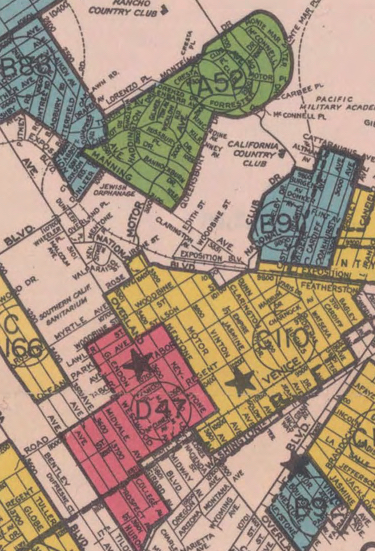
That green area at the top is Cheviot Hills, where the protagonist lived.
The street that the skate shop was on was Motor, and when it passes into Culver City, it goes into the yellow area. That’s a yellow-lined area. Yellow-lined areas were considered one grade above the redlined areas. That particular redlined area was an old Mexican area. The yellow area was populated by Italian and Jewish.
The grading system was completely racist. Areas with populations of Mexicans, Negros (the term at the time), and Orientals (the term at the time) were automatically graded “red”. Areas with working class and white collar white people were given a yellow, or sometimes blue, rating.
That blue area near the green area was a white collar area, with workers from the film industry.
The green areas were given that code if they were not just a white population, but also had restrictive covenants on property that would force the owners not to sell to the above mentioned redlined races. They often wouldn’t sell to Jews either.
Ghettos didn’t just happen. They were created by public policy, and also by private practices driven by the real estate business.
The mid 1990s were a product of public policy and geography mapped out in the 1930s.
PS – Because the area of Culver City is now getting gentrified, they filmed outdoor scenes in East Los Angeles. The trailer shows several well known East LA locations. East LA was also a redlined community in the 1930s.


Leave a Reply